 Platform // Overview
Augmented Reality
Team Awareness Kit
ARTAK is a multi-domain joint planning and command & control platform. It synchronizes planning and C2 activities across echelons, domains, and warfighting functions by bringing command and staff together into a single digital decision environment.
The headset is on us
Order a Solo, Duo or Team Starter by 31 December 2026 and the Meta Quest 3 ships with it. One year of ARTAK Block 3 on any device, in the same live 3D digital twin your team plans, briefs, and rehearses in.
Every starter sits under the $15,000 micro-purchase threshold, so a Government Purchase Card holder can buy one directly.
See all pricing- Solo Starter$3,400/yr
- 1 operator seat, hosted by Eolian
- Meta Quest 3 free through 31 Dec 2026
- PC, tablet and phone included in the seat
- Duo Starter$6,800/yr
- 2 operator seats, hosted by Eolian
- 2 Meta Quest 3s free through 31 Dec 2026
- Team Starter$14,500year 1
- 4 operator seats + Team Server license
- 4 Meta Quest 3s
- Server runs on your PC or edge server
- Remote onboarding
- Renews at $13,600/yr
Augmented Reality
Team Awareness Kit
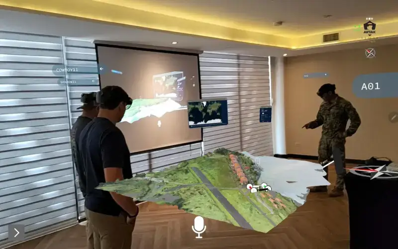 [SYS.01]
The Augmented Reality Team Awareness Kit
ARTAK Block 3 Out Now
ARTAK is a multi-domain joint planning and command & control platform. It synchronizes planning and C2 activities across echelons, domains, and warfighting functions by bringing command and staff together into a single digital decision environment. ARTAK software is device agnostic, running across AR, VR, Tablet, Phone, Laptop, and PC.
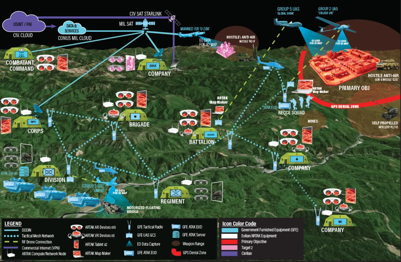 [SYS.02]
Command & Control
NextGen C2 / JADC2 Across Echelons
ARTAK is built to serve as command's heads-up display and allow for more informed decision making. Users create a session, observe the location of concern, engage with data layers, and watch their lanes. As intel becomes available it populates in real-time on the session map, alerting all users to the changing environment and enabling instantaneous understanding of the operational state.
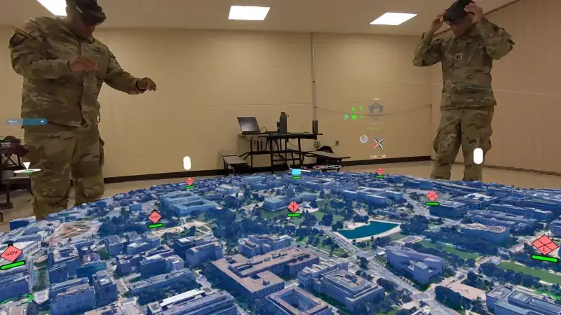 [SYS.03]
Pre-Mission Planning
Enhancing Collaboration Across Partner Forces
ARTAK deployed in preparation for and during NATO SOF 2025 to increase the efficiency and precision of planning, briefing, and rehearsal activities across both US and Partner Forces. The shared understanding and enhanced situational awareness provided by ARTAK helped enable successful execution of training missions.
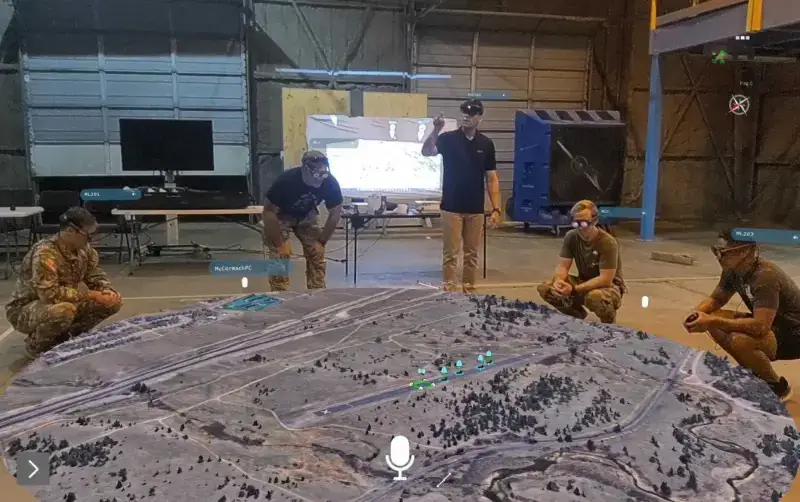 [SYS.04]
Virtual ROC Drill / Sand Table
90 Min Joint ROC Drill Conducted in ARTAK
ARTAK used to conduct a 90 minute rehearsal of concepts (ROC) drill during a joint exercise — the largest and longest brief ever conducted by a customer in ARTAK. Prior to the ROC Drill, key leaders collaborated using a realistic 3D map of the area of interest to develop the mission plan.
ARTAK Features
Core capabilities that power every ARTAK deployment — from small unit operations to enterprise command centers.
Real-Time Situational Awareness
Gain immediate insights into evolving situations with live data overlays and 3D mapping, enhancing decision-making and response times.
Enhanced Communication Channels
Facilitate seamless communication among teams with integrated voice and data sharing, ensuring everyone stays informed and coordinated.
Resource Allocation Optimization
Utilize predictive analytics to efficiently allocate resources where they are needed most, minimizing waste and maximizing impact.
Remote Collaboration Tools
Enable remote teams to collaborate effectively through virtual environments, reducing the need for physical presence and accelerating response.
Training & Simulation Modules
Prepare teams with immersive training scenarios that simulate real-world emergencies, enhancing readiness and response capabilities.
Data-Driven Decision Support
Leverage comprehensive data analysis to support strategic decisions, improving outcomes and reducing risks during crises.
Customizable User Interfaces
Adapt the ARTAK platform to meet specific operational needs with customizable dashboards and interfaces.
Scalable Deployment Options
Deploy ARTAK across various scales, from local incidents to large-scale operations, with flexible and scalable solutions.
Block 3 Release
Block 1 put a high-quality 3D map in an operator's hands at the edge. Block 2 let units build those maps themselves, without a network. Block 3 turns the map into a staff planning environment — one where you cannot drag a weapon farther than it can actually shoot.
Read the Block 3 breakdownLive Unmanned Systems Video
Live video and position from air, ground, and underwater unmanned systems, in the same shared 3D map every headset sees. Video streams from the ARTAK server to each headset; position and status arrive over ATAK. Demonstrated with eight live feeds and six tracked assets in a single session.
See the demonstrationWeapon Inventory
200+ U.S. weapon systems, each carrying its real range, engagement envelope, and blast radius — and a weapon cannot be placed beyond the range it actually has.
Doctrinal Symbology
Thousands of new icons, nodes, symbols, maneuvers, and control measures built to MIL-STD-2525E, weighted toward higher-echelon graphics.
Render-Through Graphics
Symbols and control measures draw through buildings and terrain, so a boundary or phase line never disappears behind a ridgeline or a rooftop.
Enhanced Immersion Mode
Higher-fidelity eye-level walkthroughs of building interiors, multi-floor structures, and subterranean spaces — rehearse in the actual terrain.
Six New Base Maps
Aerial and Aerial with Labels, Bing and Google Road, Earth at Night, Google Satellite and Satellite with Labels, Google Shaded Topographic, and Cesium.
Multi-User HMD Syncing
Improved headset synchronization across sessions, so every headset in the room holds the same picture at the same moment.
Search by Warfighting Function
Filter points by category and by warfighting function — what makes a dense higher-echelon plan usable.
Refined Interaction Model
Improved hand tracking, menu manipulation, and laser pointing, plus color swatches for faster, more legible node coding.
Everything Block 2 Delivered
Each Block is additive. Block 2's leap in mapping, performance and reach ships with Block 3 — nothing below was replaced.
Bigger & Better High-Quality 3D Maps
Massive terrain rendering with unprecedented fidelity and detail.
Streamlined & Improved UI/UX
Easy to use whether you're 7 years old or 70.
"World in a Box"
A 3D tiled map base layer of the entire planet.
JADC2 Live Data Stream Overlays
Real-time data from hundreds of sources at your fingertips.
Enriched Full Immersion Mode / "Room-Scale"
Complete VR immersion for total situational awareness.
Enhanced Maps for Interiors & Subterranean
Building interiors, underwater, and sub-terranean mapping.
Advanced Capabilities at the Edge
Full operational capability in disconnected, austere environments.
True MDO Across All Domains
Multi-Domain Operations across Land, Air, Sea, Space, and Cyber.
Boosted Speed, Stability & Fidelity
Decreased latency for a vastly superior user experience.
Thousands of Additional Capabilities
Expanded nodes, maneuvers, actions, settings, and customizations.
Deployable Everywhere
ARTAK software runs across the full spectrum of virtualization hardware, from immersive headsets to mobile devices.
Use Cases
ARTAK's immersive C2 platform is deployed across defense, public safety, and enterprise sectors worldwide.
 [UC.01]
Disaster Response & Emergency Management
In times of chaos, ARTAK transforms fragmented operations into a unified mission picture. Real-time drone feeds, IoT data, and geospatial overlays help command centers coordinate faster, deploy smarter, and save more lives.
Learn More- [UC.02]
Search & Rescue / First Responders
Every second matters. ARTAK integrates UAV data, terrain models, and team tracking into a shared 3D environment — enabling crews to visualize hazards, optimize routes, and train in realistic VR scenarios before entering the field.
Learn More  [UC.03]
Security & Protection Services
Whether providing security for individuals, events, or facilities, ARTAK delivers a fused operational picture — combining radar, drone, and sensor data in a single spatial interface. Agencies gain 360-degree visibility over wide or remote regions.
Learn More- [UC.04]
Police & Law Enforcement
For urban operations, crowd control, or tactical response, ARTAK provides a shared operational view that improves decision-making and reduces risk. Officers can rehearse complex scenarios in VR and access real-time overlays during live incidents.
Learn More - [UC.05]
Fire & Emergency Services
ARTAK gives fire commanders complete situational awareness — tracking crews, visualizing structure layouts, and modeling wildfire spread in 3D. Through AR and VR, teams can prepare, respond, and review every mission with confidence.
Learn More  [UC.06]
Space & Aerospace Operations
From orbital mission planning to ground-station coordination, ARTAK enables teams to visualize assets, trajectories, and contingencies in immersive 3D. It brings real-time command awareness to an increasingly complex operational domain.
Learn More
Storyboards // Field DeploymentsCase Studies
Real-world deployments across USSOCOM and partner forces demonstrating ARTAK's operational impact.
10th SFG(A) — NATO SOF 2025
10th Special Forces Group (Airborne) // NATO Special Operations Forces 2025
ARTAK was deployed in preparation for and during NATO SOF 2025 to increase the efficiency and precision of planning, briefing, and rehearsal activities across both US and Partner Forces. The shared understanding and enhanced situational awareness provided by ARTAK helped enable successful execution of multinational training missions.
US and coalition partner forces co-planned complex joint missions inside a shared ARTAK environment, enabling simultaneous visualization of terrain, forces, and scheme of maneuver regardless of language or national system.
Plan: US and NATO partner forces co-planned missions in shared ARTAK sessions
Rehearse: Joint rehearsals enabled cross-coalition coordination and shared understanding
Brief: Multi-echelon briefings delivered through ARTAK 3D visualization across US and partner SOF
Visualize: Real-time 3D terrain and force position visible across distributed coalition teams
Result: Increased efficiency and precision of planning across multinational coalition partners
Sage Eagle 25-2
3rd Special Forces Group (Airborne) // ODA 3121
3121 used ARTAK during Sage Eagle 25-2 to visualize their targets and plan various aspects of their mission. The team sourced an asset to fly a small UAS around three areas of interest.
Recon: Imagery collected autonomously using Skydio X2+ at 200 acres/hr
Process: 3D maps generated from UAS images using Map Maker (~5.5 sq KM)
Track: Position of force tracked via ATAK with GoTENNA + Starlink
Visualize: Real-time position of force visible on 3D map via Meta Quest 3
NSWG-8 TRADET
Naval Special Warfare Group 8 // Training Detachment
NSWG-8 TRADET integrated ARTAK with new COTS devices (GoTENNA, Starlink) to track, monitor and replay trainees' positions during live-fire assault and react-to-contact drills.
Monitor: Dislocated OTCs monitored exercise in ARTAK — watching real-time movements on a 3D replica of the range
Replay: OTCs and trainees replayed the exercise in ARTAK afterwards for AAR
Result: Enhanced training feedback loop with spatial context and position history
2nd Battalion, 160th SOAR — Joint ROC Drill
10–14 September 2024 // Cannon AFB, New Mexico
2/160 SOAR used ARTAK to conduct a 90-minute ROC drill during a joint exercise with US ARMY 5th SFG(A), USAF 23rd STS — the largest and longest brief ever conducted by a customer in ARTAK.
Prior to the drill, key leaders collaborated in ARTAK using a realistic 3D map to develop the mission plan. During the drill, briefers used ARTAK to rehearse while enablers viewed on AR headsets and TV screens.
Recon: Exterior imaged autonomously using Skydio X2+ at 200 acres/hr
Process: 3D maps generated using Map Maker on laptop
Plan: Leaders visualized landing zones, avenues of approach, and scheme of maneuver
Brief: 90-min ROC drill — largest/longest ever in ARTAK
View: AR HMDs + TV monitors for distributed viewing
Units: 160th SOAR, 5th SFG(A), USAF 23rd STS